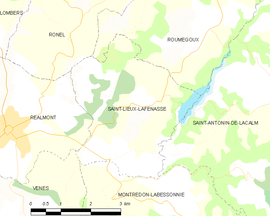
Saint-Lieux-Lafenasse
Vzhľad
| Saint-Lieux-Lafenasse | ||
| obec | ||
|
||
| Štát | ||
|---|---|---|
| Región | Midi-Pyrénées | |
| Departement | Tarn | |
| Súradnice | 43°46′5″S 2°13′45″V / 43,76806°S 2,22917°V | |
| Najvyšší bod | ||
| - výška | 365 m n. m. | |
| Najnižší bod | ||
| - výška | 197 m n. m. | |
| Rozloha | 12,19 km² (1 219 ha) | |
| Obyvateľstvo | 448 | |
| Hustota | 36,75 obyv./km² | |
| Časové pásmo | SEČ (UTC+1) | |
| - letný čas | SELČ (UTC+2) | |
| PSČ | 81120 | |
| INSEE | 81260 | |
|
Poloha obce Saint-Lieux-Lafenasse
| ||
| Wikimedia Commons: Saint-Lieux-Lafenasse | ||
| OpenStreetMap: mapa | ||
| Portály, ktorých súčasťou je táto stránka: | ||
Saint-Lieux-Lafenasse je francúzska obec, ktorá sa nachádza v departemente Tarn, v regióne Midi-Pyrénées.
Polohopis
Saint-Lieux-Lafenasse má rozlohu 12,19 km². Najvyšší bod je položený 365 m n. m. a najnižší bod 197 m n. m.[1].
Obyvateľstvo
Saint-Lieux-Lafenasse má 448 obyvateľov (2009)[2].
Graf vývoja obyvateľstva:

Zdroje: INSEE[3]
Referencie
- ↑ Répertoire Géographique des Communes [online]. Institut national de l'information géographique et forestière (IGN). Dostupné online. (po francúzsky)
- ↑ Populations légales 2009 [online] Institut national de la statistique et des études économiques (Insee). Dostupné online. (po francúzsky)
- ↑ Résultat du recensement de la population 2008 [online] Institut national de la statistique et des études économiques (Insee). Dostupné online. (po francúzsky)


