Verneuil-sur-Avre (kantón)
Vzhľad
| Verneuil-sur-Avre | |
| kantón | |
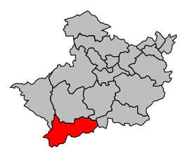
Kantón na mape obvodu Eure
| |
| Štát | |
|---|---|
| Región | Horná Normandia |
| Departement | Eure |
| Obvod | Eure |
| Súradnice | 48°44′22″S 0°55′43″V / 48,739444444°S 0,928611111°V |
| Správne sídlo | Verneuil d'Avre et d'Iton |
| Rozloha | 169,27 km² (16 927 ha) |
| Obyvateľstvo | 11 548 (2011) [1] |
| Hustota | 68,22 obyv./km² |
| Časové pásmo | SEČ (UTC+1) |
| - letný čas | SELČ (UTC+2) |
| INSEE | 2735 |
| Počet obcí | 14 |
| Portál, ktorého súčasťou je táto stránka: | |
Verneuil-sur-Avre je francúzsky kantón v obvode Évreux v departemente Eure v regióne Horný Normandie. Skladá sa z 14 obcí.
Obce kantónu
- Armentières-sur-Avre
- Les Barils
- Bâlines
- Bourth
- Chennebrun
- Courteilles
- Gournay-le-Guérin
- Mandres
- Piseux
- Pullay
- Saint-Christophe-sur-Avre
- Saint-Victor-sur-Avre
- Tillières-sur-Avre
- Verneuil-sur-Avre
Referencie
- ↑ Populations légales 2011 (xls, 8,12 MB)
Zdroj
Tento článok je čiastočný alebo úplný preklad článku Kanton Verneuil-sur-Avre na českej Wikipédii.


